
New Mexico’s largest reservoir plunges to just 1.4% full
- Date:
- September 3, 2026
- Source:
- NASA Earth Observatory
- Summary:
- Elephant Butte Reservoir, New Mexico’s largest reservoir, plunged to just 1.4 percent capacity in July 2026 after years of extreme drought and record early snowmelt. The dramatic decline exposed long-submerged debris and underscored the growing strain on Rio Grande water supplies used by farms in New Mexico and Texas.
- Share:
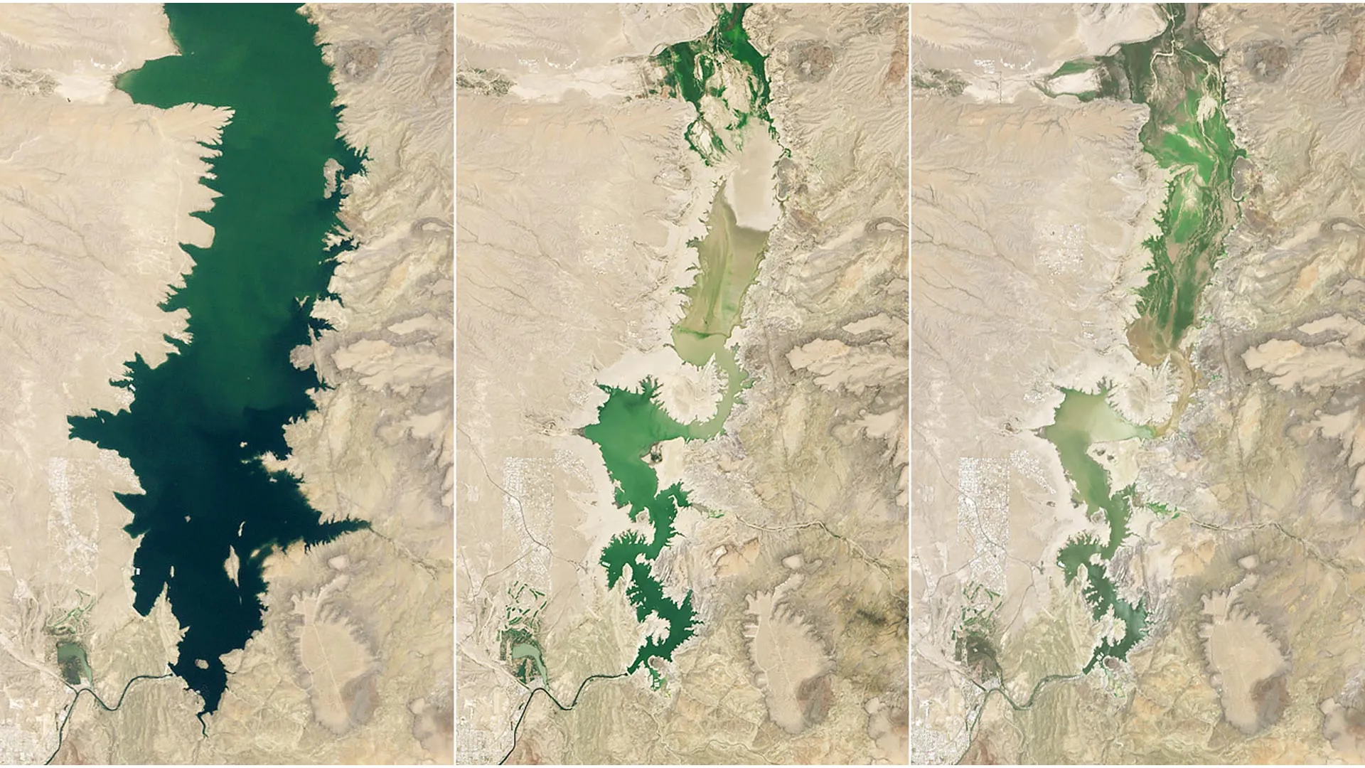
When John Glenn orbited Earth in 1962, he commented on a striking green valley northwest of El Paso, Texas, surrounded by an otherwise dry landscape. That contrast is largely the result of human-made lakes along the Rio Grande, which have made farming possible in the arid region. Irrigation supports crops including alfalfa, cotton, onions, pecans, and the area's famous Hatch green chiles.
In recent years, however, unusually dry conditions across the Rio Grande basin have placed growing pressure on those water supplies. The region has endured prolonged and extreme drought. Conditions worsened in 2026 when the river's headwaters in the southern Rocky Mountains experienced the earliest snowmelt on record.
Together, these conditions helped push Elephant Butte Reservoir, New Mexico's largest reservoir, to its lowest level since 1971. When the image above was captured on July 27, 2026 (right), the reservoir held just 1.4 percent of its capacity. By contrast, it was nearly full on June 2, 1994 (left), and water levels remained relatively high during much of the period from 1985 through 2000. During another severe drought, the lake reached its annual low of 2.9 percent capacity on July 8, 2013 (center).
Elephant Butte Falls to 1.4 Percent Capacity
The extreme decline in 2026 revealed debris that had been submerged along the shoreline and caused sediment to cover boat ramps at Elephant Butte Lake State Park. Still, the reservoir appears to have reached its lowest point of the year in late July. State officials said agricultural water releases ended after July 28, giving the reservoir a chance to slowly begin rising again.
The persistent drought has also highlighted broader concerns about the future of water along the Rio Grande. Communities and water users in both New Mexico and Texas depend on surface water and groundwater throughout the valley. Managing those limited supplies requires careful decisions about how water is stored, allocated, and shared.
NASA Satellites Help Track a Shrinking Water Supply
Several efforts backed by NASA's Western Water Action Office (WWAO) are designed to give water managers better information for making those decisions. These projects use NASA observations and analytical tools to improve understanding of water availability and support resource allocation.
One effort created a model that combines NASA satellite measurements of factors including soil moisture and evapotranspiration. The result is a near-real-time system that supplements the water allocation methods already used by the Elephant Butte Irrigation District.
Another project combined satellite measurements of water surface heights with observations from drones and instruments on the ground. Researchers used the combined data to examine how groundwater pumping influences the Rio Grande's flow, information that the WWAO says can help officials manage water rights.
NASA scientists are also participating in a federal study focused on the Upper Rio Grande. That work seeks to better understand the region's water needs, estimate how much water may be available in the future, and create data-driven tools to help managers respond to those challenges.
Story Source:
Materials provided by NASA Earth Observatory. Original written by Lindsey Doermann. Note: Content may be edited for style and length.
Cite This Page: