Super Typhoon Sinlaku triggered atmospheric gravity waves visible from space
A record-early super typhoon sent giant atmospheric ripples into near-space, offering scientists a new clue for tracking powerful storms.
- Date:
- June 3, 2026
- Source:
- NASA Earth Observatory
- Summary:
- One of the most powerful typhoons ever recorded this early in the Pacific season did more than unleash flooding and extreme winds—it sent enormous ripples all the way into the upper atmosphere. As Super Typhoon Sinlaku rapidly exploded into a category 5-equivalent storm, satellites captured rare gravity waves spreading outward like rings on a pond, visible high above Earth through a faint glow in the atmosphere.
- Share:
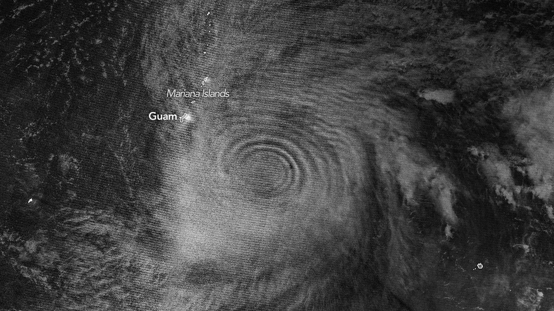
One of the Pacific Ocean's most powerful early season storms did more than bring destructive weather. As Super Typhoon Sinlaku rapidly intensified in April 2026, it also generated enormous atmospheric ripples that stretched high above Earth, offering scientists a rare glimpse into how tropical cyclones can influence everything from weather forecasting to satellite communications.
In mid-April 2026, Super Typhoon Sinlaku swept across the North Pacific, delivering heavy rainfall and flooding to the Mariana Islands. The storm reached "violent typhoon" status, the highest classification used by the Japan Meteorological Agency and roughly equivalent to a Category 5 hurricane on the Saffir-Simpson wind scale.
Meteorologists noted that only a small number of storms this intense have developed so early in the year in this part of the Pacific.
As Sinlaku strengthened over open water, satellites began detecting signs that its effects extended far beyond the storm itself. The typhoon was not only reshaping conditions at the ocean's surface but also disturbing layers of the atmosphere many miles overhead.
Satellites Capture Rare Atmospheric Gravity Waves
A nighttime image collected by the VIIRS (Visible Infrared Imaging Radiometer Suite) instrument aboard the NOAA-20 satellite revealed atmospheric gravity waves radiating outward from the storm.
These waves resemble the ripples created when a stone is dropped into a pond. In this case, they became visible through a phenomenon known as airglow in the mesosphere. Airglow occurs when atoms and molecules that absorbed energy from sunlight during the day release that excess energy as light after dark.
Scientists have long known that intense tropical cyclones generate powerful convection near their eyewalls. Heat released within the storm fuels towering cumulonimbus clouds known as "hot towers." These clouds can extend beyond the troposphere, Earth's lowest atmospheric layer, and produce waves that travel upward into the stratosphere and mesosphere.
Previous studies have found that gravity waves frequently appear when tropical cyclones are strengthening. Sinlaku followed that pattern. During the 24 hours before the satellite image was captured, the storm intensified dramatically from Category 2 strength to Category 5 strength.
"We're seeing waves propagating radially and upward, in a cone-like shape," said Joan Alexander, senior research scientist at NorthWest Research Associates.
Alexander said she was surprised by the nearly complete rings visible in the mesospheric airglow above the storm. Typically, winds in the upper atmosphere can weaken or disperse gravity waves before they reach such heights. However, relatively weak stratospheric winds at Sinlaku's latitude during April 2026 may have allowed the waves to remain intact.
Favorable Conditions Revealed the Atmospheric Rings
Viewing conditions also played an important role.
The VIIRS day-night band can detect both mesospheric airglow and reflected moonlight. On April 12, the Moon was only about 25 percent illuminated. That meant some reflected moonlight from clouds in the lower atmosphere was present, but not enough to overwhelm the much fainter airglow signal.
Gravity waves generated by Sinlaku were observed in multiple layers of the atmosphere. The AIRS (Atmospheric Infrared Sounder) instrument aboard NASA's Aqua satellite detected the waves lower down in the stratosphere on April 13.
The distinctive ripple pattern appeared again in observations collected on April 14, showing that the storm's influence on the atmosphere persisted over multiple days.
Why Gravity Waves Matter for Weather Forecasts
Scientists say studying gravity waves produced by tropical cyclones is about more than understanding an interesting atmospheric phenomenon.
According to Alexander, these waves could eventually help forecasters identify when storms are rapidly strengthening, particularly over remote parts of the ocean where direct observations are limited.
"We'd like to use gravity waves to tell us if a storm is intensifying," Alexander said, "which can be difficult to know, especially over the open ocean."
She and her colleagues have argued that a geostationary satellite equipped with the right infrared imaging technology could potentially monitor gravity waves continuously and provide new insights into tropical cyclone development.
From Winter Forecasts to Space Weather
Gravity waves also play an important role in larger atmospheric processes.
Laura Holt, another senior research scientist at NorthWest Research Associates, said weather models need to account for what happens in the stratosphere. Stratospheric wind patterns influence long range forecasts, including predictions for conditions during the following Northern Hemisphere winter.
Tropical cyclones can have an outsized impact because their powerful and sustained convection continuously drives gravity waves into the stratosphere.
The effects may extend even farther.
"For a while, people have seen signatures of hurricanes in ionospheric weather," Holt said.
Gravity waves can trigger traveling ionospheric disturbances, which are large scale ripples in plasma density. In some situations, they can also contribute to the formation of plasma bubbles. Both phenomena can interfere with satellite signals and radio communications.
"With space weather in particular," Holt added, "a single event such as a tropical cyclone can be very important."
The observations of Super Typhoon Sinlaku highlight how a powerful storm can influence atmospheric layers stretching from the ocean surface to the edge of space, providing scientists with valuable clues about weather, climate, and the technologies that depend on stable conditions overhead.
Story Source:
Materials provided by NASA Earth Observatory. Original written by Lindsey Doermann. Note: Content may be edited for style and length.
Cite This Page: