
Europe’s wildfires became so intense they created their own storm
- Date:
- August 5, 2026
- Source:
- NASA Earth Observatory
- Summary:
- Historic wildfires scorched huge areas of Spain and France, with one Spanish blaze burning an area about the size of New York City and a French fire generating a rare, towering fire cloud. A dangerous combination of lush winter growth, severe heat, drought, and strong winds helped turn the landscape into explosive fuel.
- Share:
Wildfires occur across Europe each summer, but the fires that swept through Spain and France in July 2026 ranked among the most destructive either country had experienced in decades. Some of the worst outbreaks developed in southwestern France's Gironde Department and in Spain's Ávila and Madrid provinces during the middle of the month. The fires forced hundreds of thousands of people to evacuate and destroyed hundreds of homes.
Spanish officials reported that the fire in Ávila burned about 50,000 hectares (124,000 acres), making it the largest wildfire ever recorded in the country. It surpassed the 2025 fire that affected Larouco, Quiroga, and Oencia.
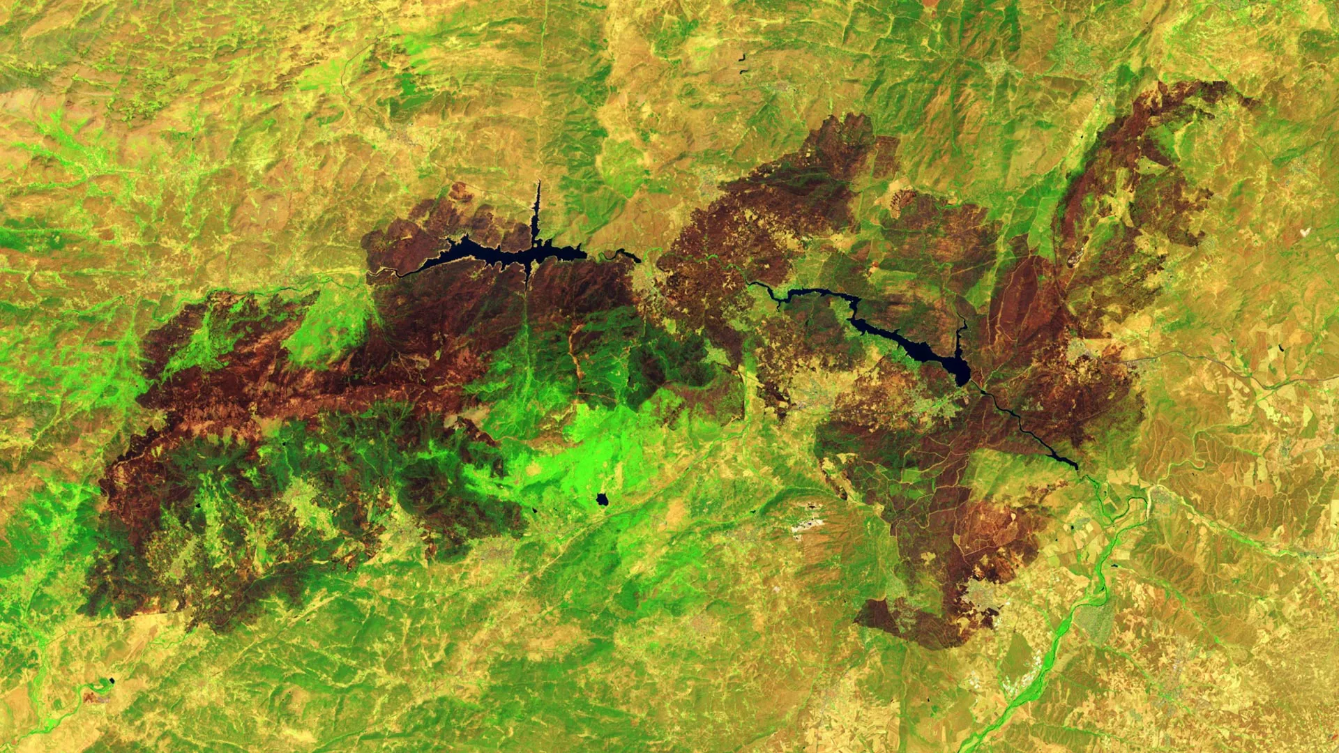
NASA satellites first detected signs of the Ávila blaze near Burgohondo on July 22 and July 23. By July 24, the fire had joined with blazes burning in nearby provinces. Together, they had scorched 77,000 hectares, an area roughly equal in size to New York City.
A Landsat 9 image taken on July 29, 2026, shows the extensive damage around Burgohondo. In the false-color view, healthy vegetation appears light green, while burned terrain appears brown. The two reservoirs near the center of the image were among the areas hit hardest.
According to news reports, flames destroyed homes, restaurants, campgrounds, marinas, and other facilities around the reservoirs.
Major Fires Sweep Southwestern France
A similarly severe emergency developed west of Bordeaux in southwestern France. One of the country's largest fires of the decade burned more than 42,000 hectares, forced widespread evacuations, and devastated the village of Le Porge.
By late July, wildfires had burned more than 90,000 hectares across France. Data from the European Forest Fire Information System showed that this was the greatest area lost to fire in the country in decades.
Weather Created a Dangerous Fire Setup
Conditions that developed months before the fires began left parts of Spain and France especially vulnerable, according to an analysis by researchers with The State of Wildfires Project.
An unusually wet winter encouraged dense plant growth across grasslands, shrublands, and forest understories. Later, repeated heat waves and a period of drought dried out that vegetation, turning it into abundant fuel.
Researchers found that several days of strong winds completed the dangerous sequence. At times, wind speeds reached 65 kilometers (40 miles) per hour, helping the flames spread rapidly across the landscape.
France Reports a Rare Fire Cloud
On July 25, the fires in southwestern France became intense enough for firefighters to report the formation of a pyrocumulonimbus -- a towering type of "fire cloud" that draws convective energy from the heat of the fires.
An international team of atmospheric scientists and wildfire specialists monitors these unusual clouds. The group has recorded occasional pyrocumulonimbus events in Spain and Portugal during recent decades, but its members said this marked the first reported case of a wildfire producing one in France.
Firefighters Battle the Blazes
Thousands of firefighters and military personnel were deployed across both countries. Aircraft dropped water and flame retardant from above, while ground crews built firebreaks with equipment ranging from bulldozers to hand tools.
By late July, firefighters had gained enough control for authorities to begin lifting some evacuation orders. Even so, forecasters warned that the danger remained high because hot and dry conditions were expected to continue.
Satellites Track Wildfires in Real Time
Government satellite observations contribute to a global monitoring system used to follow fire activity and study long-term wildfire trends.
NASA provides several tools for tracking active fires, including FIRMS (Fire Information for Resource Management System) and the Worldview browser.
Story Source:
Materials provided by NASA Earth Observatory. Note: Content may be edited for style and length.
Cite This Page: