Typhoon Jangmi’s giant eye lights up the night as it approaches Japan
- Date:
- June 3, 2026
- Source:
- NASA Earth Observatory
- Summary:
- Typhoon Jangmi powered toward southern Japan with heavy rain, strong winds, and a striking appearance from space. Nighttime satellite images revealed a large eye and intricate swirling structures within the storm. As Jangmi intensified, its outer bands spread over land, raising concerns about flooding and prolonged downpours across parts of Japan.
- Share:
A large, slow-moving storm system tracked north-northwest across the Philippine Sea toward southern Japan from late May into early June 2026. As Typhoon Jangmi advanced, its sprawling rainbands delivered intense rainfall across a broad area, prompting concerns about flooding in several locations.
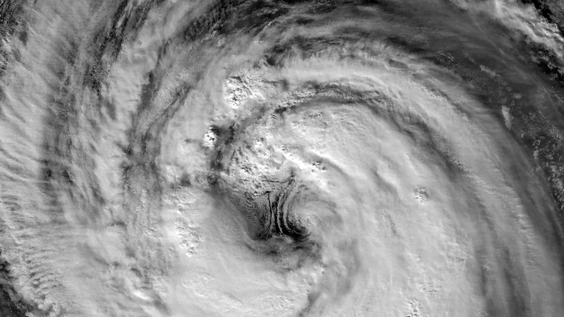
A nighttime image captured by the VIIRS (Visible Infrared Imaging Radiometer Suite) instrument aboard the Suomi NPP satellite shows the storm on May 30 at about 16:40 Universal Time (1:40 a.m. Japan Standard Time on May 31). At that time, the Joint Typhoon Warning Center (JTWC) reported sustained winds of 120 kilometers (75 miles) per hour based on 1-minute averages. That wind speed is comparable to a Category 1 hurricane on the Saffir-Simpson hurricane wind scale.
Giant Eye Visible in Nighttime Satellite Image
The satellite view provides a remarkably clear look at Jangmi's eye and surrounding eyewall. According to Scott Braun, a research meteorologist at NASA's Goddard Space Flight Center, the eye was relatively large compared with many tropical cyclones.
The image also appears to show low-level circulation along the eastern side of the eye. Those rotating features, known as mesocyclones, are partially hidden beneath higher clouds. Braun noted that while the structures are visually impressive, they are considered normal features within storms of this type.
Storm Strengthens as It Moves Toward Japan
A second satellite image, collected one day later by the VIIRS instrument on the NOAA-20 satellite, offers a wider perspective of the storm. The image was acquired at approximately 16:40 Universal Time on May 31 (1:40 a.m. Japan Standard Time on June 1).
By then, Jangmi had strengthened slightly, with sustained winds increasing to 130 kilometers (80 miles) per hour.
In both satellite views, the center of the storm remained south of Okinawa. However, Jangmi's extensive outer cloud bands had already spread over parts of Japan as the system continued its northward movement.
Flooding Concerns Along Japan's Pacific Coast
Forecasts indicated that the typhoon would pass near Okinawa before turning northeast toward the Amami region around June 1-2. Meteorologists expected the storm to continue producing significant rainfall, particularly along Japan's Pacific coastline, according to news reports.
NASA Earth Observatory images by Michala Garrison, using VIIRS day-night band data from NASA EOSDIS LANCE, GIBS/Worldview, and the Joint Polar Satellite System (JPSS).
Story Source:
Materials provided by NASA Earth Observatory. Original written by Kathryn Hansen. Note: Content may be edited for style and length.
Cite This Page: